Building practical digital tools that streamline workflows and solve real-world challenges

RINA develops practical, user-focused software solutions that help clients solve real-world engineering, construction, operations, asset management, and data challenges. Our team understands both technology and the environments in which it is used, allowing us to design and build tools that support field teams, office users, managers, and decision-makers. Whether developing custom geospatial applications, dashboards, workflow tools, integrations, or internal platforms, RINA focuses on scalable, reliable, and intuitive solutions that improve visibility, reduce manual effort, support better decisions, and create measurable business value.

Vegetation management at an electric utility is an important process not only for maintaining electric delivery reliability, but also for providing accurate and timely regulatory reporting. We partnered with Asplundh to develop a solution that takes advantage of field-collected data and business intelligence reporting to improve efficiencies in vegetation management.
Built atop the Esri platform, we were responsible for assisting in the design and development of the mobile application as well as the web-based administration tool. Our team worked closely with Asplundh stakeholders to ensure alignment with business requirements, delivering a product that has been deployed to multiple electric utilities today. This solution includes a first-of-its-kind column-based synchronization that allows end users to save edits without resulting in hundreds of conflicts with other field users. In addition, the administration tool provides the customer with a highly customizable application that can be tailored to unique needs and organizational requirements.
As one of the largest broadband providers in the US, Comcast continuously expands and maintains a complex telecommunications network. This requires fast and reliable access to infrastructure and customer intelligence data across maintenance, construction, sales, operations, and market development teams. We designed and developed custom GIS-centric applications that serve as a centralized platform for querying network assets, customers, and third-party data sources. The applications enable users to trace fiber and coax from headend to customer, visualize routes between hubs and service locations, and analyze downstream customer impacts during maintenance events and outages through integration with core customer systems.
In addition to tracing and impact analysis, the platform provides advanced network planning and strategic expansion capabilities that allow users to evaluate the feasibility and cost of new builds. GIS-driven planning tools enable estimation of routes, materials, and construction costs for individual business connections and larger market expansion areas, transforming what were once labor-intensive manual workflows into automated, geographically enabled analyses. These solutions have enabled Comcast to accelerate proactive network expansion, improve data quality and system performance, and save thousands of staff hours annually while identifying more economically viable build opportunities.
Altice USA, a subsidiary of Optimum, provides telecommunications services to more than 20 million customers across 20+ states nationwide. We partnered with Altice to modernize GIS workflows by developing Footprint, a custom JavaScript application built on ArcGIS Enterprise. Footprint enables teams to rapidly create accurate network cost estimates by drawing proposed coax and fiber routes on the map, applying cost parameters through an intuitive interface, and exporting PDF reports that include analysis of nearby customers and home passings. The application also supports "quick quotes" by calculating distances to the nearest splice, fiber, coax, or customer along the street network on the fly.
In addition to cost estimation, Footprint serves as a centralized geospatial viewer that unifies data from OSP Insight, Frontier Geotek, Bentley, and internal systems such as Netwin, Oracle, and AutoCAD into a single authoritative map. We developed and automated Python workflows to keep data current and delivered comprehensive data documentation and process diagrams to support enterprise-wide understanding. With improved access to trusted spatial data and advanced analysis capabilities, Altice has identified new expansion opportunities with the potential to generate millions of dollars in additional revenue.
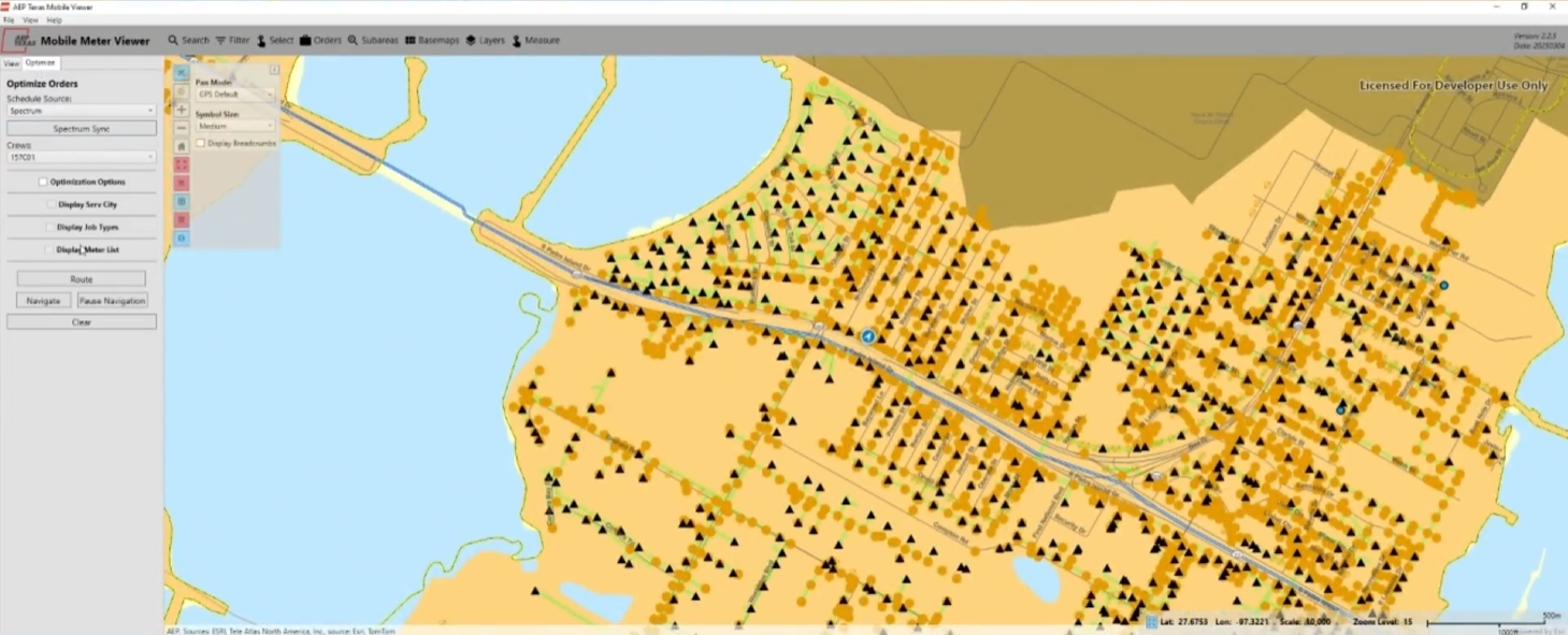
American Electric Power (AEP) utilizes a range of enterprise applications across its operating companies to support field operations, including Spectrum, a work order management system used to manage daily field tasks. Following a system-wide upgrade to smart meters, AEP Texas sought to improve field crew efficiency in planning, routing, and completing meter-related work activities, which introduced new maintenance and service requirements.
We were engaged to design and develop an offline mobile inspection application tailored to field crew workflows. Built using ArcGIS Runtime, the application supports GPS integration, configurable toolsets, and routing and directions to enhance field usability. Key capabilities include searching by serial number, premise, or address; identifying and highlighting assets; and filtering data based on operational parameters.